

Northeast Denton Area Plan
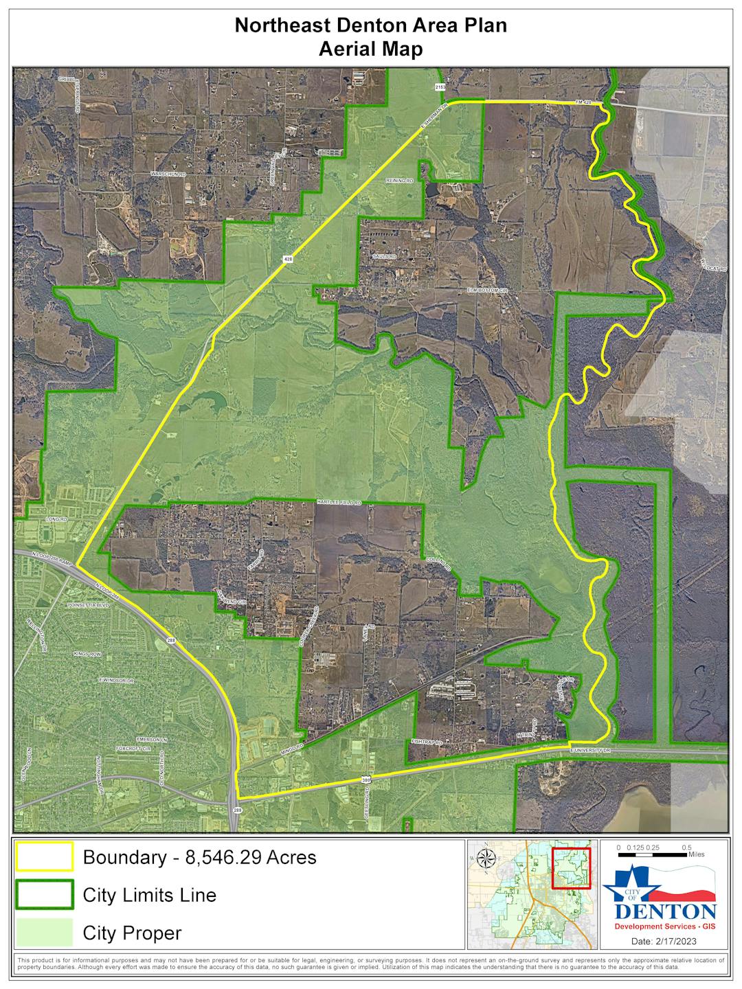
The goal of the Northeast Denton Area Plan is to establish a vision for the area, as well as set clear policy direction and supporting implementation strategies for how Northeast Denton should develop over time. The Northeast Denton Area Plan proposed study area is generally bounded by FM 428 to the north and west, Loop 288 and University Drive to the south, and the Greenbelt and Floodplain area associated with the Elm Fork Trinity River and Lake Lewisville to the east.
The main reason for the Area Plan is to respond to the development pressure that is being experienced in Denton. Recently, there have been several large development proposals and zoning change requests in this area that were denied by City Council. Major concerns raised by the community during the public hearings include the incompatible land use and density proposed, increased traffic as a result of development, lack of open space and public amenities, and the lack of overall environmental protection.
At a minimum, the following topics will be addressed in this Area Plan, as well as any additional key topics that are identified as part of the public engagement efforts: Land Use and Density; Mobility; Land Preservation/Open Space; Recreational Amenities; and Historic Preservation.
NORTHEAST DENTON AREA PLAN WILL …
- Identify areas that are important to the residents and stakeholders for preserving the rural and cultural character and environmental heritage of Northeast Denton.
- Address the development pressures being felt within and adjacent to the NEDAP area.
- Identify areas where change can occur for the advancement of the overall community.
- Suggest ideas for future improvements – transportation, housing, connectivity, parks & open space, and overall quality of life in the NEDAP area.
- Make recommendations for capital improvement projects and policy changes for future improvements in NEDAP.
Steering Committee
The Northeast Denton area is unique, so to better understand the area local experts and residents that know the history and character of the area need to be part of the planning process.
On January 24, 2023, the City Council approved a group of individuals to serve on a Steering Committee to help guide that planning process. The purpose of the Steering Committee is to provide input and feedback related to various ideas or concepts proposed, validate findings, build consensus and evaluate what is in the best interest of the project area as a whole for the longer term and for all stakeholders (not just themselves or interest groups), and be engaged throughout the duration of the project.
The Steering Committee represents a variety of community interest groups and stakeholders, individuals with diverse backgrounds and interests within the project area. Below are the names and backgrounds of the Committee members for the Northeast Denton Area Plan.
Name | Stakeholder Representation Interest |
Susan Smith* | City Resident |
Travis Ekmark* | County Resident |
Randy Smith* | City Property Owner |
Wesley Reed* | County Property Owner |
Ned Woodbridge* | Neighborhood Association/Group Liaison |
Suzi Rumohr | Bicyclist |
Vickie McGovern* | Equestrian Riding Group |
Clay Thurman | Hiking Group/Master Naturalist |
Benjamin Hokamp | Mountain Bike Group |
Eric Pruett | Planning and Zoning Commissioner |
George Ferrie | Parks, Recreation & Beautification Board Member |
Edward Soph | Sustainability Framework Advisory Committee |
Lee Ramsey | Economic Development Partnership Board |
Cassandra Berry | Historic Landmark Commissioner |
Stephen Belknap | Denton County |
* Also is a resident or property owner in the project area. | |
- There are no stories to display. Why don't you share one?
Important Documents
-
 Steering Committee Meeting #1 Agenda (53 KB) (pdf)
-
Steering Committee Meeting #1 PowerPoint Presentation (5.12 MB) (pdf)
-
Study Timeline (113 KB) (pdf)
-
Strategic Foresight Workshop PowerPoint Presentation (3.84 MB) (pdf)
-
Draft Existing Conditions Report (19.3 MB) (pdf)
-
Steering Committee Meeting #2 Agenda.pdf (13.8 KB) (pdf)
-
Steering Committee Meeting #2 PowerPoint Presentation (5.85 MB) (pdf)
-
Phase 1 | Public Engagement Feedback Summary (6.53 MB) (pdf)
-
August 1, 2023 | Joint Workshop Presentation (127 MB) (pptx)
-
November 1, 2023| Planning and Zoning Commission Special Called Work Session Agenda & Backup (19.9 MB) (pdf)

Who's Listening
-

Phone (940) 349-8381 Email angela.manglaris@cityofdenton.com -
MH
Phone (940) 349-8583 Email mia.hines@cityofdenton.com -
SR
Phone (972) 415-0914 Email shai.roos@hdrinc.com -
PT
Phone (972) 960-4106 Email Pamela.Thompson@hdrinc.com