

Northeast Denton Area Plan
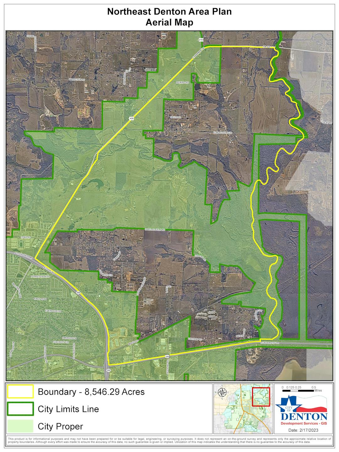
The goal of the Northeast Denton Area Plan is to establish a vision for the area, as well as set clear policy direction and supporting implementation strategies for how Northeast Denton should develop over time. The Northeast Denton Area Plan proposed study area is generally bounded by FM 428 to the north and west, Loop 288 and University Drive to the south, and the Greenbelt and Floodplain area associated with the Elm Fork Trinity River and Lake Lewisville to the east.
The main reason for the Area Plan is to respond to the development pressure that is being experienced in Denton. Recently, there have been several large development proposals and zoning change requests in this area that were denied by City Council. Major concerns raised by the community during the public hearings include the incompatible land use and density proposed, increased traffic as a result of development, lack of open space and public amenities, and the lack of overall environmental protection.
At a minimum, the following topics will be addressed in this Area Plan, as well as any additional key topics that are identified as part of the public engagement efforts: Land Use and Density; Mobility; Land Preservation/Open Space; Recreational Amenities; and Historic Preservation.
NORTHEAST DENTON AREA PLAN WILL …
- Identify areas that are important to the residents and stakeholders for preserving the rural and cultural character and environmental heritage of Northeast Denton.
- Address the development pressures being felt within and adjacent to the NEDAP area.
- Identify areas where change can occur for the advancement of the overall community.
- Suggest ideas for future improvements – transportation, housing, connectivity, parks & open space, and overall quality of life in the NEDAP area.
- Make recommendations for capital improvement projects and policy changes for future improvements in NEDAP.
-
Good to Know
Share Good to Know on Facebook Share Good to Know on Twitter Share Good to Know on Linkedin Email Good to Know linkWhy is the City doing a Northeast (NE) Denton Area Plan when there is already an adopted comprehensive plan that covers this area?
The Denton 2040 Comprehensive Plan is a high-level, visionary document that does not consider specific conditions of this area or of individual properties within the area. The Comprehensive Plan recognizes that NE Denton is a special area in the City with an overall vision of preserving green environment and environmentally sensitive land. The Comprehensive Plan recommended that NE Denton be studied in further detail to work out the specifics on how to achieve the overall vision in a manner that meets consensus, especially among the property owners and stakeholders in the area.
What are the limitations of this NE Denton Area Plan?
The NE Denton study area is 8,546.29 acres, with 3,981.85 acres (46.6%) in the City of Denton city limits and 4,564.44 acres (53.4 %) in the City’s extraterritorial jurisdiction (ETJ). Therefore, the City can only influence development in 46.6% of the study area to meet the vision established through this planning process. The other 53.4% of the study area will be influenced by the County.
What are the roles of the project team (City staff and consultants) in creating the NE Denton Area Plan?
The project team is made up of urban planners, open space experts, economists, and engineers. The project team’s role is to be facilitators. They will work to collect extensive input from a large and inclusive group of property owners and stakeholders related to what the community wants the area to be and the ways in which the community wants to achieve this vision.
To assist the community in making these decisions and develop the plan for the NE Denton study area, the project team will provide the community with research and data related to existing conditions in the area and surrounding region, and development trends in the City of Denton. The project team will also use their knowledge and expertise in urban planning and development to provide the community with possible solutions, strategies, and action steps to achieve the community’s vision.
The project team will use thought-provoking questions and deep-dive discussions to understand what the NE Denton community wants and the ways in which they might want to achieve their vision. The project team will do this both in-person and online. These questions and discussions will focus on understanding the desires of the community. Through this process, the team will provide multiple ways for the community to provide input on what the community wants to see in the NE Denton area in the future.
At the end of the planning process, the project team will package the community’s desired vision, community-chosen solutions, and proposed action steps into a plan document that will assist the City and the County in guiding the property owners and developers in the types of development that is desired in the area. The plan will differentiate between land that is in the City limits and land in the County. The NE Denton Area Plan document will help the City and the County to plan for the types of infrastructure and services that will be needed in the area based on the community’s vision.
It seems like there is huge interest and development pressure this area. Why?
- New transportation-related improvements, such as widening US 380, service roads and realignment of Loop 288, improvements to FM 428, and the alignment of the new Outer Loop along Sherman Road, are expected to improve accessibility to and from the metroplex to NE Denton.
- The NE Denton area has easy access to the University of North Texas and Texas Woman’s University, as well as to downtown Denton and its amenities.
- There are large parcels of vacant land under single ownership in the area, which is more desirable for development compared to consolidating multiple smaller parcels under different ownerships.
- According to the Dallas Regional Chamber of Commerce, the Dallas region has grown by more than one million new residents every 10 years since 1980, putting intense pressure on the region’s housing stock.
Why does the City consider zoning change requests for projects that do not match the existing zoning?
If a property owner applies for a zoning change, the City is required by State law to take the application through the process and allow the property owner to make their case to the Planning and Zoning Commission and City Council.
Why does the City consider recommendations that seem contrary to the Future Land Use Map (FLUM) in the City’s Comprehensive Plan?
In such cases, the City takes into consideration the following reasoning:
- A comprehensive plan is a conceptual and visionary document that does not consider specific conditions at a smaller subarea or individual property level.
- A comprehensive plan is a living document that must be constantly updated to reflect current conditions and social, economic, and physical changes in an area.
What can the City regulate in the ETJ?
The City only has platting authority in the ETJ. Platting is ministerial, which means that regardless of use or density, if a property meets basic service requirements such as access to water, wastewater, and roads, the City is required to approve the plat. The City can specify minimum lot size only if a property needs a septic system. If a property in the ETJ is serviced through municipal or regional water/wastewater system, the City has no authority to regulate lot size or setbacks in the ETJ.
What can the City do to preserve open space?
- Buy property and designate it as park space.
- Use zoning power in an area to:
- Specify lower-density uses
- Establish large lot requirements and require larger setbacks from the property line
- Specify cluster development resulting in open space conservation
However, a city can only do this within the city limits while following state law regarding property rights.
Why can’t the City buy property for parks in the area?
- The City has a limited budget and must balance providing services to all parts of the City equally.
- Some larger property owners are not willing to sell land to the City.
What is cluster development?
Cluster development – also called open-space development or conservation development – is an attempt to achieve balance between growth and preservation of open space in rural and suburban settings. It is done by clustering homes on a smaller proportion of land. The additional land, which would normally be allocated to individual lots across the entire subdivision, becomes protected as common space. Depending on the site, the common space may protect wetlands, floodways, steep-grade slopes, farmland, wildlife habitat, woodlands, archaeological resources, historic or cultural resources, or groundwater resources.
The example below shows three different scenarios on a 100-acre wooded site: before development, developed with 2-acre lots, and developed using cluster development.
 1https://www.mass.gov/
Beyond achieving site-specific goals of open-space preservation, cluster development attempts to connect open spaces from one development to the next, creating an interconnected network of farmland and conservation land. Conventional development patterns fragment open space into disconnected parcels, severely limiting the amount of suitable wildlife habitat and doing little to create a visual sense of contiguous open space.
By contrast, cluster development places dwellings in areas hidden from existing roads in order to preserve view corridors and rural aesthetics. In many cluster developments, municipal trail networks are included with the goal of one day connecting to each other to form a regional trail system.
-
Phase 1 | Public Engagement Summary
Share Phase 1 | Public Engagement Summary on Facebook Share Phase 1 | Public Engagement Summary on Twitter Share Phase 1 | Public Engagement Summary on Linkedin Email Phase 1 | Public Engagement Summary link
STAKEHOLDER INTERVIEWS- Interviewed 25 stakeholders
- Elected & appointed officials (7)
- Residents (7*)
- Large landowners (4*)
- Developers (3*)
- Agencies - TxDOT, USACE, County (9)
* Some individuals are counted twice as both large landowners & study area residents or large landowners & developer
VISIONING WORKSHOPS
- 265 attendees (in-person)
- Community at-large
- In-person
- Online Survey
STRATEGIC FORESIGHT WORKSHOP
- 39 attendees
- Students and professors (12**)
- Elected and appointed officials (10)
- Residents (10**)
- Large land landowners (5**)
- Developers and real estate professionals (5**)
- Natural systems professionals (6**)
** Some individuals are counted twice as both large landowners & study area resident or large landowners & developer or resident & professor or natural systems & students/professors
-
Strategic Foresight Workshop
Share Strategic Foresight Workshop on Facebook Share Strategic Foresight Workshop on Twitter Share Strategic Foresight Workshop on Linkedin Email Strategic Foresight Workshop linkFORMAT
- Collaborative process that brings together a diverse group of stakeholders to explore potential futures
- There were 5 tables and each table had 8 to 9 participants from various backgrounds and ages to ensure inclusion of all current & future residents and interests throughout the 8,500-acre study area
ACTIVITIES
- Each table was asked to work collaboratively to:
- Analyze and sort future trends by high/low impact and high/low certainty
- Build a scenario based on a future positive disruption, negative disruption, “Blue skies” (perfect future) or no change
- Collect common themes
- Create a vision statement based on trends and common themes

TREND ANALYSIS
- Top high impact/high certainty trends:
- Climate change
- Infrastructure overhaul
- Mass migration
- Rural versus urban division
- Reduced community engagement
- Fiscal uncertainty
- Top high impact/low certainty trends:
- New financial partnerships
- Focus on hyper-localization
- Nomadic workforce
- Increase in off-gridding
- Top low impact/high certainty:
- Electric vehicles,
- Micro grids,
- Tech-enabled healthcare

COMMON THEMES
- Take care of the environment: green development, green infrastructure, rural character, open space, green/clean energy.
- +Improve infrastructure: micro grids, clean power.
- +Support outdoor lifestyle: space for biking/walking, active transportation.
- +Work together: find consensus, care about each other, plan for the future.
- +Diversity of housing: range of types, prices, locations, styles throughout Denton. Diversity of architecture (no cookie-cutter subdivisions). Housing affordability. Multi-generational design/accessibility. Plan for aging in place.
- +Live/work/play environment: create a village with open space, retail, etc.
- +Majority agreed on “No Apartments” but not all

DEVELOPMENT OF VISION STATEMENT PROCESS
- Participants at each table at the Strategic Foresight Workshop were given a choice of creating their own vision statements from scratch using the common themes from the five scenarios, OR
- Enter the common themes in Chat GPT to get a vision statement as a starting point
- The majority participants chose to use Chat GPT as a starting point and then word smithed that statement to develop 8 different statements (including the Chat GPT statements)
- Following the Strategic Foresight Workshop, an online survey was conducted where the public at large voted on these 8 vision statements. The online survey also gave a choice to add people’s own statement if they did not like any of the 8 statements developed at the workshop.
- The Steering Committee at their meeting on May 30, 2023, will finalize the vision statement.
-
Community Visioning Open House - Summary
Share Community Visioning Open House - Summary on Facebook Share Community Visioning Open House - Summary on Twitter Share Community Visioning Open House - Summary on Linkedin Email Community Visioning Open House - Summary link
At the Open Houses held on Thursday, March 23, 2023 and on Saturday, March 25, 2023 community members participated in input activities to understand opportunities and constraints from the community's point of view in the study area. The input activities included the following:
INPUT ACTIVITIES
1) One Thing to Keep and One Thing to Remove Activity Tables
This activity helped determine the most important desires of the community by asking: “If you could keep only one aspect of the northeast Denton area, what would it be? And if you could remove one aspect of the northeast Denton area, what would it be?” Participants wrote their thoughts on a sticky note.
2) Front Page Headlines Activity Table
This activity asked community members to write on a sticky note a newspaper headline about Northeast Denton in 2050.
3) Vision Boards Activity Table
This activity helped the community members picture the future vision for the area. Participants used red and green dots to indicate the images they can envision or cannot envision in the Northeast area.
4) Opportunities and Constraints Activity Table
Participants used markers to show opportunities and constraints – areas that should be areas of focus for change. These could include dangerous intersections, proposed park space, new trails, good locations for shopping, historical areas to be preserved, informal gathering areas, vacant property that could be better used, wider (or smaller) streets needed, etc.
5) Six Word Story Activity Table
The Six-Word Story encouraged participants to be creative while providing telling information about the core sentiment of their experience of a place. The Six-Word Story attempts to distill a person’s experience or narrative into a short, evocative story. This is an exercise in brevity while conveying meaning and substance. Example: “For sale: baby shoes, never worn.” Participants write their six-word story on sticky notes and add them to the wall.
6) Discussion Table
This table provided participants an avenue for additional discussions with more detail and a broader range of topics. Questions from the online survey prompted discussion with community members
7) Children’s Area
This activity encouraged children to be part of the conversation shaping Northeast Denton’s future. The creative activity asked children to envision the future they want.
OPEN HOUSE SUMMARY
At the first Community Visioning Open House there were 168 participants that attended the event. At the second Open House there were 97 participants that attended. Below is a summary of what we heard from the community:
Newspaper headline in 2050
- Rural Country Living Character
- Outdoor Recreational Greenspaces
- Preserve Hartlee Field
- Low Density Residential
- Protect/ Conserve Natural Systems
- No More Apartments
- Control Developments
- Road resurfacing – Cooper Creek Road
- Change back to pre 2000 vision
- Compromise through input that all parties are content with
One thing to KEEP in NE Denton
- Open space, trees, greenbelts
- Keep zoning “as is”
- Low density rural development
- Keep Hartlee Field Road a rural cross section
- Farms & cattle
- Hartlee Field Airstrip & hangars
One thing to REMOVE from NE Denton
- Apartments
- Traffic
- Mixed use development/density
- PD zoning/ tract homes
- Traffic safety measures
- Future growth
- Homeless
- Planning & Zoning Commission
- Junk yards not in use
- Woodhaven Mobile Homes
For more summary details refer to Phase 1 | Public Engagement Feedback Summary PowerPoint under Important Documents.
-
Community Visioning Open House
Share Community Visioning Open House on Facebook Share Community Visioning Open House on Twitter Share Community Visioning Open House on Linkedin Email Community Visioning Open House link
Open House Dates and Times:
Thursday, March 23, 2023 | 6 to 8 p.m.
Saturday, March 25, 2023 | 4 to 6 p.m.
Location: Hodge Elementary School Cafeteria, 3900 Grant Pkwy.The City of Denton is preparing a Northeast Denton Area Plan to:
- establish a long-term vision and plan for the area to shape its future character
- communicate desired types of development and preferred locations
- identify opportunities for land preservation
- direct public investments.
This plan will set clear policy direction and include supporting implementation action items. As part of creating this plan, the City is holding a Northeast Denton Area Plan Community Visioning Open House to obtain input and feedback from residents and business owners. Here are the topics we will talk about and want your feedback on:
- Land Use and Dens
- Mobility
- Land Preservation/Open Space
- Recreational Amenities
- Historic Preservation
- Additional topics identified as part of public engagement efforts
Each open house will cover the same information. Staff will be available to discuss the plan and answer questions from those in attendance.
Important Documents
-
 Steering Committee Meeting #1 Agenda (53 KB) (pdf)
-
Steering Committee Meeting #1 PowerPoint Presentation (5.12 MB) (pdf)
-
Study Timeline (113 KB) (pdf)
-
Strategic Foresight Workshop PowerPoint Presentation (3.84 MB) (pdf)
-
Draft Existing Conditions Report (19.3 MB) (pdf)
-
Steering Committee Meeting #2 Agenda.pdf (13.8 KB) (pdf)
-
Steering Committee Meeting #2 PowerPoint Presentation (5.85 MB) (pdf)
-
Phase 1 | Public Engagement Feedback Summary (6.53 MB) (pdf)
-
August 1, 2023 | Joint Workshop Presentation (127 MB) (pptx)
-
November 1, 2023| Planning and Zoning Commission Special Called Work Session Agenda & Backup (19.9 MB) (pdf)

Who's Listening
-
Phone (940) 349-8381 Email angela.manglaris@cityofdenton.com -
MH
Phone (940) 349-8583 Email mia.hines@cityofdenton.com -
SR
Phone (972) 415-0914 Email shai.roos@hdrinc.com -
PT
Phone (972) 960-4106 Email Pamela.Thompson@hdrinc.com